Madrid, Spain – In the intricate dance of diplomacy, the lines of a map can shift like whispers in the wind, igniting fires where calm once reigned. Such is the case in Spain, where a quiet oversight has now sparked a storm across international waters, drawing eyes from near and far.
The issue lies not in the deep-rooted territorial debates between Spain and the United Kingdom over Gibraltar, but in the unintentional admission of a boundary that Spain has long contested. Two Spanish ministries—those meant to uphold the nation’s sovereignty—now find themselves at the center of this growing tension. Their official portals, dependent on collaborative mapping software, have mistakenly recognized Gibraltar’s sovereignty over the surrounding waters.
A Misstep in the Waters: Ministries at the Helm of Controversy
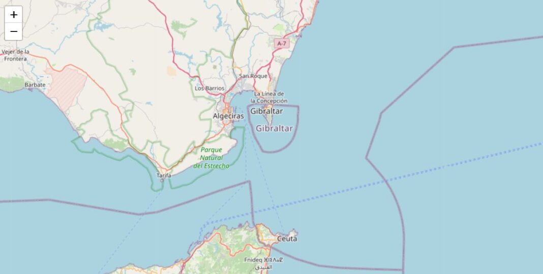
What began as a simple oversight has become a flashpoint. The Ministry for the Ecological Transition and the Demographic Challenge, along with the Ministry of the Interior, released maps that show Gibraltar’s waters encircling the iconic rock, a small peninsula that has stood at the crossroads of history. Spain has long asserted its claim over these waters, yet here, on official Spanish portals, the lines trace a circle of ownership belonging to the British territory.
The maps in question—one displaying strategic noise maps and the other, a hydrocarbon geoportal—unintentionally acknowledge Gibraltar’s sovereignty in a way that Spain has fought for decades to deny. Even the Directorate General of Traffic’s road network maps succumbed to this same error, portraying the contested waters as part of Gibraltar’s domain.
“The Cartographer’s Error”: An Unwitting Admission on Spanish Soil
But this was no diplomatic shift or official change in stance. As reported by Europa Sur, the erroneous boundaries are not rooted in political decisions. Instead, they result from the use of OpenStreetMap—a widely used, freely collaborative mapping tool. In a world increasingly reliant on digital mapping, such software is often a go-to resource, pulling from user-generated data that is open to interpretation.
Though innocent, this error cuts deep, especially as it coincides with a territorial dispute that remains sensitive to the Spanish people. The misstep reflects how even in the digital age, where borders are drawn can hold more weight than mere pixels on a screen.
Global Eyes Turn to Spain: Panic or Misunderstanding?
Across the seas, the issue has caught the attention of international media. Olive Press, a publication with ties to both Spain and Germany, stirred the pot further, claiming “Panic in Spain” as news of this mishap spread. The narrative has quickly moved beyond the Spanish coastline, reflecting how even minor errors, when tied to historic grievances, can lead to widespread alarm.
Lessons in Sovereignty: The Human Cost of a Digital World
Spain’s struggle with the Rock of Gibraltar is not new, but this latest event shows that in the modern age, even digital representations can ripple into reality. The story stretches beyond the cartographic mistake, tapping into the hearts of nations and reminding us how deeply we remain connected to the land and waters around us.
For Spain, this incident becomes not just a tale of oversight but of the enduring weight of sovereignty and history. It reminds us of the unseen hands that craft the maps we follow and the quiet power they hold in shaping the world we see.
In these contested waters, Spain must now reclaim its narrative, correcting the digital footprints left behind. But for those who look closely, this is not just a story of lines on a map, but of the stories those lines tell—of history, of pride, and of a land still fiercely defended.


